How to find true south for aligning solar collectors
For any solar project you typically want your solar collectors (solar panels, vacuum tubes, ...) to be facing true south if you're in the northern hemisphere or true north if you're in the southern hemisphere. True south or true north are where the sun will be at its highest during the day. Unfortunately simply using having a compass needle aligned north-south isn't good enough.
To keep things simple, below we'll focus on finding true south. The same ideas work for finding true north but simply have to be reversed.
True south versus magnetic south
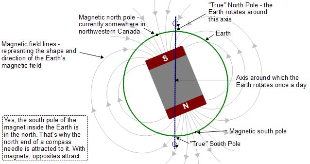
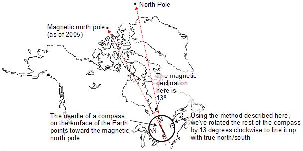
When a compass needle points south, it doesn't point to the south pole (unless you're in one of the very rare locations where it does.) Why not? Because a compass needle points to the magnetic south pole and not the south pole you always hear about in Antartica. The same is true for a compass used in the northern hemisphere where the needle points to the magnetic north pole and not the north pole that the Earth rotates around.


Basically the Earth contains a giant magnet and it's not aligned with the Earth's rotation. A compass needle is just a tiny magnet and lines up with the poles of that giant magnet, not the poles that the Earth rotates around.
Finding out your latitude and longitude
Some of the methods below require you to find out your latitude and longitude. Here's how you can.
Using wikipedia
Go to wikipedia.org and look up your city or one near you. The latitude and longitude are given in the box on the right near the top of the page.Using Google maps
Another way is to go to maps.google.com and find your place. Then right-click on your place for a menu and select "What's here?". The edit box above the map should then give you two values. The first is your latitude and the second is your longitude. If the latitude is a positive number then it's north latitude (i.e. north of the equator) and if it's a negative number then it's south latitude (i.e. south of the equator.) If the longitude is a positive number then it's west longitude (i.e. west of the Greenwich, England) and if it's a negative number then it's south longitude (i.e. east of Greenwich, England.)Method 1: The shortest shadow method
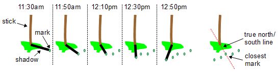
Place a stick standing straight up in flat ground on a day when it's sunny out around midday. The stick's shadow will appear on the ground. When the sun is highest in the sky, the shadow will be the shortest it will be that day and it will be aligned with true south and true north.
The stick must be straight up with respect to the center of the Earth and the ground where the shadow will be must be flat and perpendicular to the stick at all points. If the ground is uneven or slanted with respect to the stick then the shadow may be at its shortest when the sun is not at its highest.
To make sure the stick is straight up, tie a weight to one end of a string and hold on to the other end of the string. Once the weight is hanging and not swaying around, the string is now straight up with respect to center of the Earth. Make the stick match the orientation of the string or just use the string itself instead of a stick.
To find the shortest shadow, every few minutes as the shadow moves make a mark in the ground at the end of the shadow. After the shadows start getting longer instead of shorter look for the mark that is closest to the base of the stick. A line between that mark and the base of the stick is aligned with true south/north.
Method 2: Using a shadow at solar noon
Perhaps the simplest way to find true south is to wait until noon and then look at your shadows. The edges of the shadows of things that are perpendicular to the earth/standing straight up line up with true south/north.
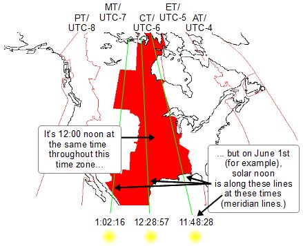
However, as the diagram below shows, 12:00 noon is not necessarily the right time. You actually want solar noon. Solar noon is the moment when the sun crosses the meridian line for your location and when the sun is the highest in the sky. 12:00 noon standard time is the same for the entire time zone that you live in but the sun can't be highest at the same time for every point across that entire time zone! Solar noon is different across the entire time zone.
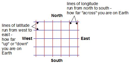
A meridian is a line of longitude, a line extending from the true north pole to the true south pole.
One way to find solar noon is to find out what times sunrise and sunset are. Solar noon is midway between those times. Sunrise and sunset times are often in local newspapers and weather websites.
To find solar noon you can also use an online calculator. Here's a popular one. You'll need your latitude and longitude (see the section above if you don't know how to get these.)
Once you know when solar noon is, go outdoors when the sun is out and look at shadows of things that are aligned straight up, such as the edge of a building. If there are none where you plan on putting your collector then bring along a stick or just use your body to make a shadow.
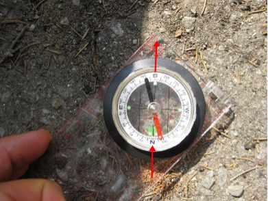
Method 3: The compass method
You'll need a compass that has degree marks on it. Line up your compass needle north-south like you normally would. Then find out how many degrees and which direction magnetic north is relative to true north. This is called the magnetic declination and you can find out your's by going to any of a number of websites, for example NOAA's Geomagnetism page here. Rotate your compass by the amount indicated by your magnetic declination and the "S" on your compass will now be pointing to true south.
Note: It's best to do this outdoors, away from buildings since things inside a building can cause a compass to point in directions other than magnetic north.
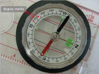
Example of adjusting a compass to find true south (and north)
Step 1. Find your magnetic declination: To find you magnetic declination NOAA's website allows you to give it your zip code if you're in the US, or select a city from many places around the world, otherwise you can give it your latitude and longitude. If you don't know how to find your latitude and longitude, see the section above that tells you how. Ottawa, Ontario, Canada is at latiture 45° 25' north, longitude 75° 41' west. So for Ottawa, by giving NOAA's page above 45 25 north and 75 41 west, we get a declination of 13 degrees and 26 minutes west.
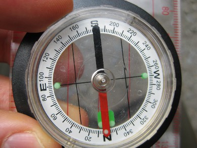
Step 2. Align your compass needle north-south: Place your compass flat so that the needle can move freely and rotate it horizontally so that one end of the needle points to the letter "N" and the other end to the "S". Then "N" should now be pointing to magnetic north.
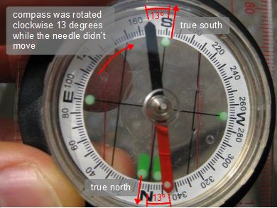
Step 3. Adjust the compass needle for the magnetic declination: If NOAA's website told you your declination was some number west then rotate your compass clockwise by the number of degrees indicated by your declination. In the case of Ottawa it was 13 degrees west so we'd rotate it 13 degrees clockwise. If NOAA's website told you your declination was some number east then rotate the compass counterclockwise instead.
The "S" on the compass should now be pointing to true south.
Method 4: Using Google Earth
Find your location using Google Earth and look at how it's oriented with respect to the lines of longitude. To tell Google Earth to display lines of longitude, go to the View menu and select Grid. The lines of longitude are the ones marked E (east) or W (west) along their lengths. There's also a dial in the top right corner with an N displayed on it. The N stands for north and the dial is a sort of compass which you can turn to rotate the view. Rotating the N to the top of the dial makes true south be the bottom of the view.
Google Earth is free and is easily downloadable from http://earth.google.com.
